 Home page / Accueil du site


Biography in Nice west, on the french riviera
Family tree patterns : 4 générations,6 générations, agnatique 9 générations...
This page is part of François Nespola's bioraphy, Nice 1858-1911,click here to see the intro and here to see the table of contents
1787, Nice , western area. Countrysides.

Direct link to Acadèmia Nissarda http://www.gravures-nice.org/.
Extrait de Voyage pittoresque Nice, Bibliothèque de Cessole.
The engravure is old (1787). On the right, we can see a couple on Magnan bridge. The woman protects herself from the sun with an ombrella. Around, big farms, villas on the hills. The tower in the middle, close to the sea, is on the Baumette area. Continuing on the left, there are fields and the river banks of the Paillon. On the right bank, toward us, we can guess a few houses, just sketched there in light white. It's the area of "La croix de marbre". On the left bank of the Paillon, the old Nice Snuggled up in the feet from the hill of the castle. No castle to see on this castle hill. It has been destroyed in 1706 by Louis XIV. A single tower remains, Bellanda tower, you can see it, in light grey just above the Beaumette tower. The castle hill makes the first cape, behind it's the entrance of port Lympia. The second cape is cape of Nice, beyond there is Villefranche natural harbour and Saint-Jean-cap-Ferrat peninsula ended by the lighthouse.
In 100 years, with the incorporation of Nice to France, Nice is going to take its current shape. In 1860, the city spreads up to Magnan.
Actual map of Nice


View of St Antoine de Ginestiere from Terron.
François Nespola spent all his life in the West of Nice. He was born in 1858 at Ginestière and was christened in Saint-Antoine de Padoue, church of the village.
In history, French and Austrians Au cours de l'histoire, Français et Autrichiens fought for Nice and the armies alternately laid siege to it.By safety, the Inhabitants of Nice lived behind the ramparts of the old town or in villages perched on hills. They also dreaded the raids of barbaresques by the sea. The last invasion, Napoleon's italian campaign lead to the incorporation of Nice to France, with the creation of the Alpes-Maritimes department.
With the extension of Nice, the village became the area of «Saint Antoine de Ginestière».
Later François lived in the area of Sainte-Hélène close to the sea front.
In these days, Nice center and Promenade des Anglais stopped at Magnan, a small river which owned its name to the breedings of silkworms, in french "magnaneries". Western laid the countryside.
 Fishermen on the "Promenade des Anglais", watercolor of Antoine TRACHEL,1828-1903.
Direct link to Acadèmia Nissarda http://peintres.nicehistorique.org
Fishermen on the "Promenade des Anglais", watercolor of Antoine TRACHEL,1828-1903.
Direct link to Acadèmia Nissarda http://peintres.nicehistorique.org
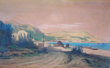
From Magnan up to the small village of Carras, it was the area of Barri de maçon, name used in 1800, then become « barimasson ». It was mainly an area of gardens, gravel shore and pastures. , était essentiellement une zone de jardins, de gravières et de pâturages. The littoral zone seem very thin.It is traveled by the road of France, become main road in 1860, then avenue of California. On its hills, large properties of several hectares inhabited in winter by rich families or dedicated for olive trees. We guess the St Hélène church bell tower, the actual airport headland and Antibes cape with its lighthouse.
 vue depuis Carras, 1850
David SUTTER
Direct link to Acadèmia Nissarda http://peintres.nicehistorique.org
From Carras toward East, we can guess the old city of Nice behind his ramparts. Some country houses and farms along the shore. The small cabins of the fishermen and their boat "les pointus" (sharp boat), small boats they dragged on the shore, there was no harbour.
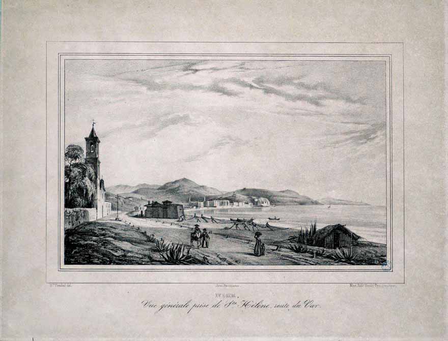
splendid site of Acadèmia Nissarda http://www.gravures-nice.org Sainte-Hélène au XVIIIème siècle (lithographie) - Musée Masséna - Bibliothèque de Cessole
On this engravure, we can see Sainte-Hélène church, the road of France and a military fort ....
 In spite of its classic, rather modern aspect, this church is old, 1646-1656. The blog http://saintluc.over-blog.fr/ tells its story. The church was founded in 1728 and was the first church in the country side around Nice. Although little away from Carras, because built on private domain and bequeathed by the family Rossignoli, it was the church of the villagers.
For family research, the first registers you can read on the net date from 1728. (link to the first register)
The General Council of the Alpes-Maritimes counts 2.837 baptisms in this church during the Sardinian restoration from 1814 till 1860 among which 155 Martin and 127 Falicon, what does not facilitate the searches on the genealogy of these familes. ( link to baptisms 1814-1860 )
After 1860, date of Nice's incorporation in France, the expansion of Nice westward has been very strong .
The city first gathered in the old part "le vieux Nice", below the castle hill then spread gradually westward.1787, Nice , western area. Countrysides.
Direct link to Acadèmia Nissarda http://www.gravures-nice.org/.
Extrait de Voyage pittoresque Nice, Bibliothèque de Cessole.
The engravure is old (1787). On the right, we can see a couple on Magnan bridge. The woman protects herself from the sun with an ombrella. Around, big farms, villas on the hills. The tower in the middle, close to the sea, is on the Baumette area. Continuing on the left, there are fields and the river banks of the Paillon. On the right bank, toward us, we can guess a few houses, just sketched there in light white. It's the area of "La croix de marbre". On the left bank of the Paillon, the old Nice Snuggled up in the feet from the hill of the castle. No castle to see on this castle hill. It has been destroyed in 1706 by Louis XIV. A single tower remains, Bellanda tower, you can see it, in light grey just above the Beaumette tower. The castle hill makes the first cape, behind it's the entrance of port Lympia. The second cape is cape of Nice, beyond there is Villefranche natural harbour and Saint-Jean-cap-Ferrat peninsula ended by the lighthouse.
In 100 years, with the incorporation of Nice to France, Nice is going to take its current shape. In 1860, the city spreads up to Magnan.
Actual map of Nice
View of St Antoine de Ginestiere from Terron.
François Nespola spent all his life in the West of Nice. He was born in 1858 at Ginestière and was christened in Saint-Antoine de Padoue, church of the village.
In history, French and Austrians Au cours de l'histoire, Français et Autrichiens fought for Nice and the armies alternately laid siege to it.By safety, the Inhabitants of Nice lived behind the ramparts of the old town or in villages perched on hills. They also dreaded the raids of barbaresques by the sea. The last invasion, Napoleon's italian campaign lead to the incorporation of Nice to France, with the creation of the Alpes-Maritimes department.
With the extension of Nice, the village became the area of «Saint Antoine de Ginestière».
Later François lived in the area of Sainte-Hélène close to the sea front.
In these days, Nice center and Promenade des Anglais stopped at Magnan, a small river which owned its name to the breedings of silkworms, in french "magnaneries". Western laid the countryside.
The areas of Fabron, Sainte-Hélène and Carras. The Barrimasson.
The Barrimasson
Fishermen on the "Promenade des Anglais", watercolor of Antoine TRACHEL,1828-1903.
Direct link to Acadèmia Nissarda http://peintres.nicehistorique.org From Magnan up to the small village of Carras, it was the area of Barri de maçon, name used in 1800, then become « barimasson ». It was mainly an area of gardens, gravel shore and pastures. , était essentiellement une zone de jardins, de gravières et de pâturages. The littoral zone seem very thin.It is traveled by the road of France, become main road in 1860, then avenue of California. On its hills, large properties of several hectares inhabited in winter by rich families or dedicated for olive trees. We guess the St Hélène church bell tower, the actual airport headland and Antibes cape with its lighthouse.
Carras, small fishermen village.
vue depuis Carras, 1850David SUTTER
Direct link to Acadèmia Nissarda http://peintres.nicehistorique.org
From Carras toward East, we can guess the old city of Nice behind his ramparts. Some country houses and farms along the shore. The small cabins of the fishermen and their boat "les pointus" (sharp boat), small boats they dragged on the shore, there was no harbour.
Sainte-Helene church and the registers for Carras genealogy
splendid site of Acadèmia Nissarda http://www.gravures-nice.org Sainte-Hélène au XVIIIème siècle (lithographie) - Musée Masséna - Bibliothèque de Cessole
On this engravure, we can see Sainte-Hélène church, the road of France and a military fort ....
In spite of its classic, rather modern aspect, this church is old, 1646-1656. The blog http://saintluc.over-blog.fr/ tells its story. The church was founded in 1728 and was the first church in the country side around Nice. Although little away from Carras, because built on private domain and bequeathed by the family Rossignoli, it was the church of the villagers.
For family research, the first registers you can read on the net date from 1728. (link to the first register)
The General Council of the Alpes-Maritimes counts 2.837 baptisms in this church during the Sardinian restoration from 1814 till 1860 among which 155 Martin and 127 Falicon, what does not facilitate the searches on the genealogy of these familes. ( link to baptisms 1814-1860 )
More frequent names on baptisms registry 1814-1818
- Martin, 155 baptisms
- Falicon, 127
- Seasseau (Seassal) 107
- Bensa (Benssa,Benza), 71
- Maiffret (Maifret), 70
- Auda, 64
- Bessi, 60
- Gilli, 57
- Lambert, 54
- Brun, 53
- Bertagna, 48
François Nespola'life, 1858-1911
It was marked by the profound restructuring of Nice from its incorporatin to France in 1860:- The bridge above the Var, 1845-1862
- The train 1864
- Nice capital of flowers
- The great properties
- The extension of Promenade des Anglais in 1884 from Magnan to Carras
- and at the same date, The enchantment of the électricté displayed for the universal exposition of Nice on the plateau of Piol.
 historic context: Nice, Savoie-Piémont-Sardaigne